Stretches of the Mighty Grynner Highway in Barbados are very dark at night despite the presence of many businesses and pedestrians.

Walking in Fear: Inside the Everyday Survival Strategies of Women in Barbados

On a quiet night about 25 years ago, Ann stepped out of a work event in St Michael and into a darkness that would alter the rest of her life. The Barbados journalist, who asked to be identified by a pseudonym to protect her privacy, was robbed and raped at gunpoint while waiting for a ride in a poorly lit area. The trauma has never loosened its grip. Now, every time she leaves home, safety frames her decisions. “All of my plans are based on ensuring my personal safety,” she said.


Aerial view of the abandoned rubber fields on Non Pareil Estate in 2025

Trinidad’s Forgotten Rubber Industry

When the world shut down during the early months of the COVID-19 pandemic, one of the most unexpected shortages was not food, fuel, or electronics, but rubber.

Hospitals struggled to acquire gloves, syringes, ventilator seals and fundamental protective equipment as global supply chains collapsed.

This shortage uncovered modern society’s dependence on natural rubber, a material whose unique properties contribute to its functionality and versatility.


Remnants of Sediment Trapping Units (STUs) at Weg naar Zee, showing how earlier nature-based efforts to capture mud and rebuild the coastline have deteriorated over time

Battling the Waves at Weg Naar Zee

At the northwestern edge of Suriname’s capital, Paramaribo, the Atlantic Ocean relentlessly batters the shoreline. Here lies Weg naar Zee – literally “Road to the Sea” – long regarded as one of the country’s most vulnerable coastal zones. According to demographic data from the Central Bureau for Civil Affairs, the area had 14,047 registered residents with Surinamese nationality in 2024, placing thousands of people directly in the path of advancing tides. Standing in the heart of this fragile territory, it becomes clear that the question is no longer whether the sea will advance, but at what rate. The backyard of farmer Soerinderpersad Ganpat once dipped and swelled like an improvised battlefield, crossed by a clay ridge meant to hold back the sea.


Two Weeks Later, Relentless Resilience Amidst Hurricane Melissa’s Aftermath

As the sun rises each morning over the battered coasts and battered communities, the scars left by Hurricane Melissa are everywhere. For miles all that can be seen are toppled power lines, damaged homes, and families struggling to regain a sense of normalcy. Yet, across the most-affected regions, a story of remarkable resilience and determination is unfolding. Hurricane Melissa struck Jamaica on October 28, 2025, as a Category 5 storm and it left a trail of destruction across vast stretches of the island, plunging entire communities into darkness and disrupting lives overnight. Torrential rains and hurricane-force winds devastated critical infrastructure and forced emergency officials into round-the-clock action.


Is Barbados Keeping Cruise Tourism and Marine Protection on an Even Keel?

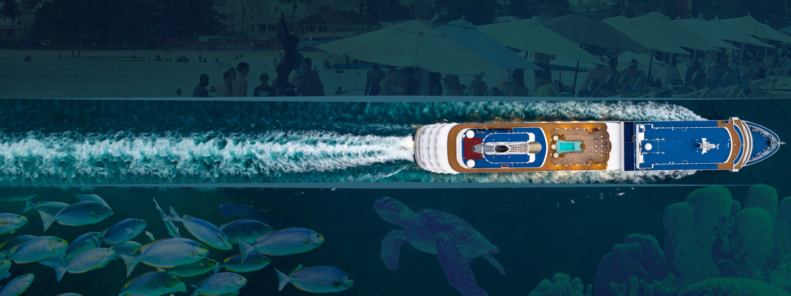
Cruise passengers wait anxiously to disembark. When the doors finally open, they scurry down the gangway into waiting taxis and buses, eager to see what Barbados has to offer. 

The most coveted destination is the beach, where the dreams of some vacationers come true as they experience “advertised” paradise. This paradise is part of the larger marine space, which Barbados agreed to protect as a signatory to the United Nations’ Convention on Biological Diversity and later,  the Kunming–Montreal Global Biodiversity Framework (GBF) in December 2022. The framework outlines 23 target action goals, with Target 3 focusing on 30% marine protection by 2030. 

Cementing its dedication to the 30×30 goal, Barbados entered into a debt-for-nature swap, legally tying its financial recovery to its environmental commitment. 

Despite these highly visible international stances and the Marine Areas (Preservation and Enhancement) Act, Cap 392; the Coastal Zone Management Act, Cap 394; and the Marine Pollution Control Act, Cap 392A Acts, Barbados protects less than 1% of its marine space through its sole legally designated Marine Protected Area, the Barbados Marine Reserve. This reserve, located at Folkestone on the west coast, is protected by law and divided into four zones for research, recreation, and water sports. 

The Barbados Marine Reserve, located on the west coast, and Carlisle Bay Marine Park on the south coast, together account for less than 1% of the island’s marine space under official protection.


Information Portal Hurricane Melissa

Since 2017, the Media Institute of the Caribbean has championed initiatives grounded in the principles of Media and Information Literacy, especially in the face of misinformation and disinformation. Committed to advocating for accurate information, we are supporting journalists, media workers, and the public following Hurricane Melissa. To help, we have set up a simple Google Drive folder with daily reports from various infrastructural and emergency sources. This project is made possible through the assistance and cooperation of the Jamaica Chamber of Commerce. Inside the folder, you’ll also find useful link pages to ODPEM, humanitarian organizations operating on the ground, and other key resources.